How are tigers counted in India?

Prime Minister Narendra Modi will release the much-awaited tiger census data at a mega event in Mysuru on Sunday to commemorate the 50th anniversary of "Project Tiger".

During 'Amrit Kaal,' he will also release the government's vision for tiger conservation and also launch the International Big Cats Alliance (IBCA). Furthermore, the Prime Minister will also launch a commemorative Rs 50 coin in honour of the project.
India launched Project Tiger on 1 April 1973 a concerted effort toward saving the big cat, which had been facing extinction at the time. Initially, it covered nine tiger reserves spread over 18,278 sq km. At present, there are 53 tiger reserves spanning more than 75,000 sq km (approximately 2.4 per cent of the country's geographical area).
Over the last 50 years, their numbers have gone up thanks to concentrated efforts under the 'Project Tiger'. India now has around 3,000 tigers, more than 70 per cent of the global wild tiger population, and the number is increasing at a rate of 6 per cent per year.
How are tigers counted in India?
From dense jungles to the Himalayas, tigers are an elusive species and is not an easy process to count the Tiger number.
In 1973, when the first Tiger census was conducted forest staff would use glass and butter paper to track tiger pugmarks. Every tiger has a unique and individual footprint like human fingerprints that helps in tracking. Over the years the practice evolved into a statistical method of counting.
For the tiger survey, India is divided into five zones, namely the Gangetic Plains, Central India and Eastern Ghats, Western Ghats, North Eastern Hills and Brahmaputra Flood Plains, and Sundarbans.
According to National Tiger Conservation Authority, the Tiger census is conducted using a double sampling approach to estimate the distribution and abundance of tigers in India. The first component of the double sampling consists of ground surveys of all potential tiger bearing forests in 18 States wherein the following information is collected by the State Forest Department personnel:
• Ground surveys for determining occupancy of habitat patches by tigers and other predators
• Line transects to estimate prey abundance
• Sampling plots on the line transects to assess
• Habitat characteristics
• Human impacts and
• Prey dung density.
Alongwith the information generated by the ground surveys, latest remotely sensed data on (a) landscape characteristics, (b) human "foot-print", and (c) habitat attributes are subsequently used to model tiger occupancy and abundance.
The second component of the double sampling consists of (a) scientifically rigorous abundance estimation in select sampling units using a remote camera trap based capture recapture technique for estimating tiger and other carnivore abundance and (b) line transect based Distance sampling for estimating prey abundance.
Remote camera trap photography is the most extensively used method to identify the tigers across the length and breadth of the parks. It involves photographing individual tigers who uniquely identifiable by their stripe patterns -- just like pugmarks, tigers have unique stripe marks on their body that help in identifying individuals.
In total, the camera traps captured 34,858,623 photographs of wildlife (76,651 of which were tigers and 51,777 were leopards; the remainder were other native fauna). From these photographs, 2,461 individual tigers (excluding cubs) were identified using stripe-pattern-recognition software.
-
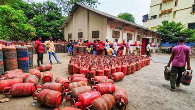 LPG Crunch: Karnataka Brings New SOPs, Makes PNG Registration Mandatory for Businesses
 -
 Hyderabad Gold Silver Rate Today, 30 March 2026: Check Fresh 24K, 22K, 18K Gold And Silver Prices In City
 -
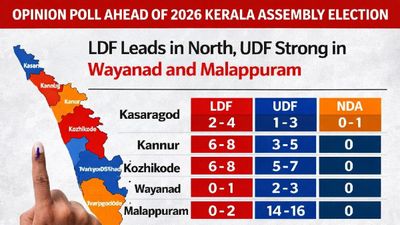 Opinion Poll For Kerala Assembly Election 2026: Ldf Strength In Kannur And Kasaragod
 -
 Tamil Nadu Polls 2026: Vijay Reveals Rs 645 Crore Assets, Rs 266 Crore in Banks; Know All His Declaration
 -
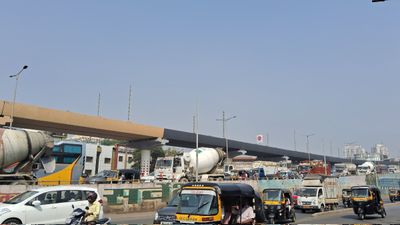 Mumbai Metro Line 9 Set for April 3 Launch, Dahisar-Mira Bhayandar to Get Direct Boost
 -
 Trump Hints At Breakthrough With Iran Amid War Escalation, Calls Recent Move A ‘Sign Of Respect’
 -
 Rahul Arunoday Banerjee Autopsy Report: Actor Was Underwater For Over An Hour, Sand Found In Lungs
 -
 West Bengal Assembly elections: Election Commission transfers heads of 173 police stations
 -
 Delhi Weather Brings Relief: IMD Issues Yellow Alert For Rain, Thunderstorms And Gusty Winds; Check Forecast
 -
 Tamil Nadu Elections 2026: Vijay Files Nomination Same Day as MK Stalin, Sets Up Symbolic Political Face-Off
 -
 Too Close To Call? 57 Key Seats Could Decide West Bengal Election 2026 As TMC And BJP Gear Up For Tight Battle
 -
 IPL 2026 RR vs CSK Live Streaming: How to Watch Rajasthan Royals vs Chennai Super Kings Match Today


 Click it and Unblock the Notifications