Karnataka Under Orange Alert: When Will Monsoon Hit Bengaluru? IMD Warns Of Severe Weather

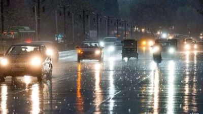
Karnataka Weather Alert: The India Meteorological Department (IMD) has issued a series of weather alerts across Karnataka, warning of heavy to very heavy rainfall, thunderstorms, lightning, and gusty winds throughout the week. With the monsoon poised to hit Kerala within the next 2-3 days, pre-monsoon activity is intensifying across the southern peninsula.

Red and Orange Alerts for Several Districts
On May 22, the IMD has issued a Red Alert for Uttar Kannada and Hassan, warning of extremely heavy rainfall and severe weather. This is the highest level of weather warning and indicates a potential risk to life and property.
The following districts are under Orange Alert, indicating the likelihood of very heavy rainfall:
- Belgaum
- Dharwad
- Shimoga
- Udupi
- Chikmagalur
- Dakshina Kannada
On May 23, Uttar Kannada and Hassan remain under Orange Alert, signaling continued high rainfall risk.
Meanwhile, several districts across Karnataka witness intense rainfall, with totals exceeding 100 mm in just 24 hours. Take a look:
Regional Subdivision Warnings
Coastal Karnataka
From May 22 to May 28, Coastal Karnataka is forecast to receive very heavy rain, along with thunderstorms, lightning, squalls, and strong surface winds. Orange warnings are in place for the entire period, indicating a prolonged period of intense weather activity.
North Interior Karnataka
Yellow alerts have been issued for this region from May 22 to 28. The IMD predicts heavy rainfall and thunderstorms with lightning over several districts, particularly active from May 22 to 25.
South Interior Karnataka
South Karnataka will also experience heavy to very heavy rainfall, especially on May 23 and 24. Thunderstorms and gusty winds (30-40 kmph) are expected in several areas, as indicated by yellow and orange alert levels.
Bengaluru Weather Forecast (May 22-25)
Residents of Bengaluru city and urban district (BNG Urban) can expect the following conditions:
May 22-22: Generally cloudy skies with light to moderate rain/thundershowers accompanied by gusty winds (30-40 kmph).
May 23-25: Generally cloudy skies with moderate rain/thundershowers and gusty winds continuing at 30-40 kmph.
Commuters are advised to carry rain gear, and localized waterlogging is possible during peak showers.
Southwest Monsoon Set to Arrive in Kerala Within 2-3 Days
In a significant meteorological update, the IMD has confirmed that conditions are turning favourable for the onset of the southwest monsoon over Kerala within the next 2 to 3 days. This marks the beginning of the 2025 monsoon season across India.
When Will Monsoon Hit Bengaluru?
The IMD has forecast that the southwest monsoon may reach Karnataka, including Bengaluru, by the end of May-earlier than its typical onset in early June. Reports also suggest that parts of the state are likely to receive above-average rainfall this season.
Meteorological Systems Behind the Activity
Low Pressure Over Arabian Sea
A low-pressure area has developed over the east-central Arabian Sea near the south Konkan-Goa coast, influenced by an upper air cyclonic circulation. This system, noted at 5:30 AM IST on May 22, is expected to move northward and intensify into a depression within 36 hours. The associated circulation extends to middle tropospheric levels.
Active Weather Troughs
A trough extends from this low-pressure system to north Telangana at approximately 3.1 km above mean sea level.
Another trough is observed in the middle tropospheric westerlies around 85°E longitude, north of 25°N latitude.
Cyclonic Systems Across India
Punjab & Neighbouring Areas: Upper air cyclonic circulation at 1.5 km.
Northeast Madhya Pradesh & Southeast UP: Another cyclonic circulation at the same height.
Central to Northeast India: A trough extends from Punjab through Haryana, Rajasthan, and Madhya Pradesh.
Northeast Assam and Arunachal Pradesh: Cyclonic circulation up to 3.1 km above mean sea level.
Advisory to Public and Authorities
- The IMD strongly advises residents in red and orange alert zones to:
- Avoid unnecessary travel
- Stay indoors during thunderstorms and lightning
- Monitor updates from local authorities and emergency services
Fishermen in the coastal areas are warned against venturing into the sea due to the high risk of squalls and rough conditions.
With the monsoon knocking on India's doorstep, the coming days promise turbulent weather. State agencies and disaster response teams have been put on high alert to ensure public safety and minimise disruption.
-
 Gold Silver Rate Today, 30 March 2026: City-Wise Prices, MCX Update On 24K Gold, 22K Gold And Silver
 -
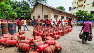 LPG Crunch: Karnataka Brings New SOPs, Makes PNG Registration Mandatory for Businesses
 -
 Hyderabad Gold Silver Rate Today, 30 March 2026: Check Fresh 24K, 22K, 18K Gold And Silver Prices In City
 -
 Opinion Poll For Kerala Assembly Election 2026: Ldf Strength In Kannur And Kasaragod
 -
 Tamil Nadu Polls 2026: Vijay Reveals Rs 645 Crore Assets, Rs 266 Crore in Banks; Know All His Declaration
 -
 Mumbai Metro Line 9 Set for April 3 Launch, Dahisar-Mira Bhayandar to Get Direct Boost
 -
 Hyderabad Gold Silver Rate Today, 31 March 2026: Gold And Silver See Fresh Movement, Check Latest City Rates
 -
 Gold Silver Rate Today, 31 March 2026: City-Wise Prices, MCX Trend As Gold Rises And Silver Slips
 -
 Rahul Arunoday Banerjee Autopsy Report: Actor Was Underwater For Over An Hour, Sand Found In Lungs
 -
 Thunderstorm Warning In Delhi NCR: IMD Issues Orange Alert Amid Sudden Weather Shift
 -
 Trump Hints At Breakthrough With Iran Amid War Escalation, Calls Recent Move A ‘Sign Of Respect’
 -
 UP STF Nabs Maulana Abdullah Salim Over Controversial Comment On CM Yogi's Mother


 Click it and Unblock the Notifications